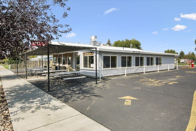
Property Record
235 E Center St, Kamas, UT 84036


NEARBY LISTINGS FOR SALE OR LEASE
-
-
View all Kamas listings for sale on LoopNet.com
Property Detail
235 E Center St
Heber, UT
Kamas Townsite Survey
KT-148-A
PARCEL 1: BEG 7.5 RODS E OF THE SW COROF BLK 33 OF THE KAMAS TOWNSITE SURVEY; & RUN TH E 119.75 FT; TH N 7 RODS 14 FT;TH W 119.75 FT; TH S 7 RODS 14 FT TO THE PLACE OF BEG CONT 0.36 ACRES PARCEL 2: BEG 15 RODS E FR THE SW COR OF BLK 33 OF KAMAS TOWNS
Commercialbuilding
Summit
X
Utah
49043C0969D
0.37 AC
2025
Outlying Summit County
2025
Salt Lake City
964202
DEMOGRAPHICS near 235 E Center St
1 Mile
3 Mile
5 Mile
2024 Total Population
1,446
3,494
5,099
2029 Population
1,404
3,423
5,136
Pop Growth 2024-2029
(2.90%)
(2.03%)
+ 0.73%
Average Age
37
36
38
2024 Total Households
475
1,145
1,716
HH Growth 2024-2029
(4.00%)
(3.23%)
+ 0.12%
Median Household Inc
$85,126
$87,704
$89,299
Avg Household Size
2.90
3.00
2.90
2024 Avg HH Vehicles
3.00
3.00
3.00
Median Home Value
$578,488
$602,908
$627,424
Median Year Built
1995
1996
1997
Nearby Places
Map Layers
Map Styles
 Street
 Aerial
- Restaurants
- Banks
- Shops
- Fitness
- Groceries
PUBLIC TRANSPORTATION
AIRPORT
Provo Municipal
DRIVE
WALK
Distance
Provo Municipal
68 min
49.8 mi
SALE & LEASE HISTORY
LISTING DATE
SALE/LEASE

Sep 29, 2021
For Sale
Aug 17, 2022
For Sale
Nearby Properties
Address
Land Use
TOTAL SIZE
Lot Size
Zoning
Address
Land Use
TOTAL SIZE
Lot Size
Zoning
5,204 SF
10.89 AC
Address
Land Use
TOTAL SIZE
Lot Size
Zoning
9.64 AC
Address
Land Use
TOTAL SIZE
Lot Size
Zoning
58,140 SF
4.78 AC
Address
Land Use
TOTAL SIZE
Lot Size
Zoning
1,308 SF
23.61 AC
Address
Land Use
TOTAL SIZE
Lot Size
Zoning
33,884 SF
7.12 AC
Address
Land Use
TOTAL SIZE
Lot Size
Zoning
3.09 AC
Address
Land Use
TOTAL SIZE
Lot Size
Zoning
2,488 SF
30.03 AC
Address
Land Use
TOTAL SIZE
Lot Size
Zoning
20,205 SF
1 AC
Address
Land Use
TOTAL SIZE
Lot Size
Zoning
20,090 SF
2.36 AC
Address
Land Use
TOTAL SIZE
Lot Size
Zoning
2.26 AC
Address
Land Use
TOTAL SIZE
Lot Size
Zoning
780 SF
2.36 AC
Address
Land Use
TOTAL SIZE
Lot Size
Zoning
30,623 SF
2.29 AC
Address
Land Use
TOTAL SIZE
Lot Size
Zoning
19,486 SF
1.22 AC
Address
Land Use
TOTAL SIZE
Lot Size
Zoning
9,887 SF
0.46 AC
Address
Land Use
TOTAL SIZE
Lot Size
Zoning
13,471 SF
17.80 AC
Address
Land Use
TOTAL SIZE
Lot Size
Zoning
15,120 SF
2.56 AC
Address
Land Use
TOTAL SIZE
Lot Size
Zoning
Address
Land Use
TOTAL SIZE
Lot Size
Zoning
16,941 SF
2.50 AC
Address
Land Use
TOTAL SIZE
Lot Size
Zoning
16,686 SF
3.25 AC
Address
Land Use
TOTAL SIZE
Lot Size
Zoning
20,520 SF
4.29 AC
Address
Land Use
TOTAL SIZE
Lot Size
Zoning
5,119 SF
26.96 AC
Address
Land Use
TOTAL SIZE
Lot Size
Zoning
23,928 SF
1.01 AC
Address
Land Use
TOTAL SIZE
Lot Size
Zoning
4.38 AC
Address
Land Use
TOTAL SIZE
Lot Size
Zoning
13,020 SF
40.92 AC
Address
Land Use
TOTAL SIZE
Lot Size
Zoning
2,352 SF
27.76 AC
Address
Land Use
TOTAL SIZE
Lot Size
Zoning
30.23 AC
Address
Land Use
TOTAL SIZE
Lot Size
Zoning
9.92 AC
The World's #1 Commercial Real Estate Marketplace
Connect with us
© 2026 CoStar Group
The information above has been obtained from sources believed reliable. While we do not doubt its accuracy we have not verified it and make no guarantee, warranty or representation about it. It is your responsibility to independently confirm its accuracy and completeness. Any projections, opinions, assumptions, or estimates used are for example only and do not represent the current or future performance of the property. The value of this transaction to you depends on tax and other factors which should be evaluated by your tax, financial, and legal advisors. You and your advisors should conduct a careful, independent investigation of the property to determine to your satisfaction the suitability of the property for your needs.